- Small ruminant and horse density explained 35% of vegetation degradation
- Increasing trends in hotspots of livestock density in the south-central and southeastern regions, whereas medium-density clusters in the northern and northwestern regions of KZ.
- Socioeconomic driver impacts were amplified when interacting with environmental drivers.
- Remote sensing combined with gridded socioeconomic data helps quantify anthropogenic impacts on vegetation degradation
How is land cover/use changed?
Kazakhstan (KZ) experienced significant land cover shifts with degradation and growth in 52.02% and 47.98% of the vegetated area. Land use change (i.e., grazing) is the predominant contributor, with small ruminants (20.37%) and horses (14.1%) having the dominant impact. Land use-dominated hotspots were evident in northern and northwestern regions in contrast to climate-dominated hotspots of vegetation degradation concentrated in the western and southern provinces.
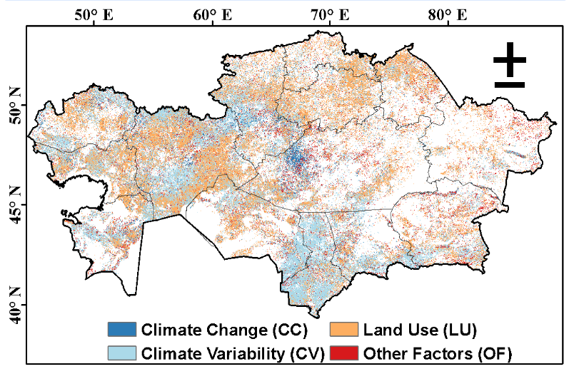
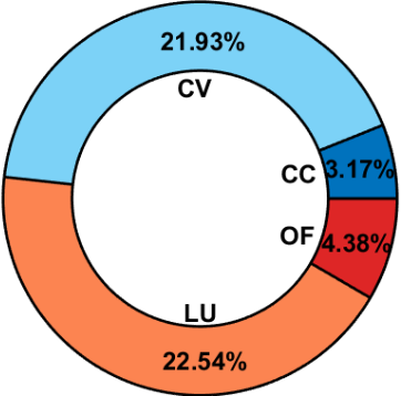
Figure 1: Dominant pixels and percentage contribution of land use (LU), climate change (CC), climate variability (CV), and other factors (OF), to vegetation changes in Kazakhstan.
Why is this Important?
Vegetation degradation due to increasing livestock, significant climate variability, and recent warming impacted vegetation growth, affecting drylands in Central Asia. Our research helps to: (1) optimize grazing locations considering water availability, and rainfall variability, and (2) develop supplemental feedstock for livestock during non-growing seasons and extreme winters
How satellite data are being used to inform decision making and Earth Action?
Integrating remote sensing data with statistical and machine learning models helped identify hotspots of vegetation degradation and distinguish climate-dominated ecosystems from land-use-dominated ecosystems. The developed maps will help as an atlas to pinpoint locations where restoration projects could have a greater impact in achieving Land Degradation Neutrality (SDG 15.3) in KZ

[1] Kolluru et al. (2022). Environ. Res. Lett., 17(9), 095007. [2] Kolluru et al. (2022). Sci. Total Environ., 847, 157562. [3] Chen et al. (2022). Environ. Res. Lett., 17(2), 023001.
Project Investigators: Dr. Jiquan Chen, Michigan State University, Email: jqchen@msu.edu; Dr. Ranjeet John, University of South Dakota; Email: Ranjeet.John@usd.edu The opinions expressed are solely the PIs and do not reflect NASA's or the US Government's views.