- Counterdrug interdiction pushes cocaine trafficking into biodiverse landscapes.
- Analyses integrating remote sensing and socioeconomic data can identify and quantify land use/cover-change caused by illicit economies.
- Urgent need for such analyses to inform action to mitigate climate change and biodiversity loss in Central America.
- NASA’s role in Earth observation is essential for evaluating long-running U.S. policies.
- Long-term effects of U.S. drug policy undermine international conservation efforts.
How is land cover/use changed?
Accelerated forest loss throughout the Mesoamerican Biological Corridor (MBC) has coincided in space and time with a shift to Central America as the primary ‘transit zone’ for cocaine trafficking [1]. Counterdrug interdiction of cocaine shipments moving northward from South America have had the unintended consequence of pushing cocaine traffickers into protected areas and indigenous territories [2], [3]. The result has been rapid and widespread loss of forest cover, biodiversity and carbon sinks. Cocaine trafficking has accounted for an estimated 15% to 30% of annual national forest loss in Guatemala, Honduras, and Nicaragua over the past decade, and 30% to 60% of that loss occurred within nationally and internationally designated protected areas [1].
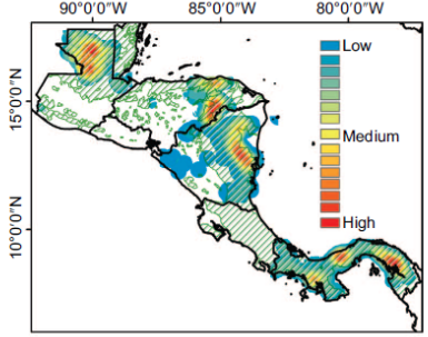
Figure 1: Density of forest loss patches with unusually large and rapid change (i.e., ‘anomalous) correlated in space and time with cocaine shipments [1].
Why is this Important?
Illicit economic activities are relatively low risk and highly lucrative generating US$91 to $259 billion per year in global value [4-6]. In response to law enforcement pressure, new cocaine smuggling routes disproportionately target protected areas and indigenous territories that are critical for achieving climate change mitigation and biodiversity conservation goals [2]. Full accounting of such collateral damages should be considered when assessing the current counterdrug strategy and potential drug policy reforms.
How are satellite data being used to inform decision making and Earth Action?
Innovative remote sensing data and methods are being leveraged to corroborate novel socioeconomic data sources (e.g., media reports, court records, field ethnographies) to isolate specific locations and times of cocaine trafficking’s influence on LCLUC. Quantifying the LCLUC caused by cocaine trafficking highlights the long-term implications of current counterdrug interdiction practices.
 [1] Sesnie et al., (2017). Environ. Res. Lett., 12(5), 054015. [2] Magliocca et al. (2019). PNAS, 116(16), 7784-7792. [3] Magliocca et al. (2022). Land. Urban Plan., 221, 104359. [4] Gore et al. (2019). Nat. Sustain., 1–3. [5] Nellemann et al. (2016). UNEP. [6] Tellman et al. (2020). Nat. Sustain., 3(3), 175–181.