- Rapid urbanization is occurring within secondary cities, particular in Africa, which need more data and analyses to understand how urban change in occurring and its implications.
- Secondary cities provide great socio-economic opportunities, but rapid growth creates challenges for management, sustainable development, and provisioning of resources.
- Multi-tiered approaches are needed to merge the monitoring of broad urbanization patterns with characterizations of heterogenous urban land cover within cities consistently.
- The current era of remote sensing technologies provides opportunities for multi-scale data fusions to analyze urbanization patterns and implications across scales.
How is land cover/use being changed?
Urbanization continues to be one of the leading drivers of LCLUC globally, although African countries appear to be at the forefront of these current urban expansion trends [1]. Much of this rapid growth is occurring in small to medium sized secondary cities. While secondary cities are becoming the new vital economic centers for large regions of the world, often providing refuge for urban residents seeking a higher quality of life [2], many of these cities are also experiencing the negative consequences of unplanned development.
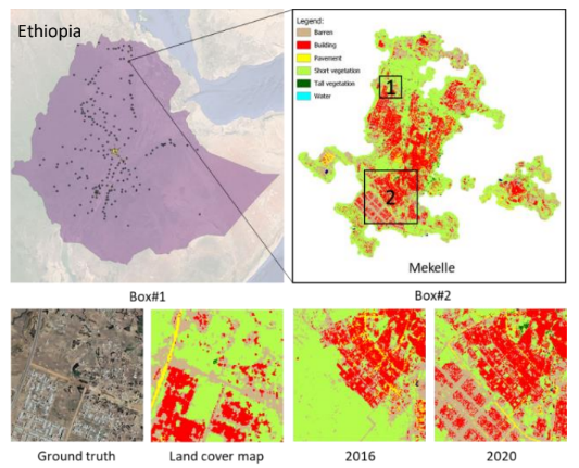
Figure 1: Case study county (Ethiopia) showing multi-tiered mapping scales including national extent 30m resolution land use maps for 2016-2020 (only showing identified hotspots), and then 10m resolution urban land cover products developed
across all identified urban areas at national extents.
Why is this Important?
To date, the study of urbanization and its consequences has occurred at two very different scales and resolutions: 1) large extent, lower resolution studies of LCLUC and 2) focal scale, higher resolution studies of urban heterogeneity. One is good for understanding urban growth, while the other captures landscape quality, human- environmental interactions, and trade-offs in ecosystem services.
How satellite data are being used to inform decision making and Earth Action?
Within our study, we leveraged multiple sources of remote sensing imagery at varying resolutions to develop a multi-tiered urban LCLUC mapping approach that captures larger urbanization patterns while still quantifying the heterogeneity of urban land covers across three African case study countries: Ethiopia, Nigeria, and South Africa.

[1] United Nations 2017. https://population.un.org/; [2] Roberts 2014, Cities Alliance: Cities without Slums.
Project Investigator: Dr. Jody Vogeler, Colorado State
University, Colorado, USA; Email: jody.Vogeler@colostate.edu
The opinions expressed are solely the PI's and do not reflect NASA's or the US Government's views.