- Agricultural expansion in the Brazilian Cerrado drives the loss of primary vegetation and the gain of irrigation for export-oriented monocultures of soy, maize, and cotton.
- Climate change reduces water availability, increases water demand, and aggravates socio-ecological conflicts.
- Understanding irrigation, specifically its distribution, effectiveness, and alternatives, is essential for understanding adaptation to climate change.
- Development of LCLUC methods is essential to analyze drivers and impacts of land change.
How is land use/cover changing?
The northeastern region of the Brazilian Cerrado is one of the most active agricultural frontiers worldwide. The region is experiencing extensive and often illegal deforestation to increase crops and pastures, which has included a 150-fold increase in irrigation between 1985 and 2016. Meanwhile, rainfall has decreased by 12% since 1980, reducing the regional aquifer and river discharge. Regional agribusinesses continue to invest in soy, maize, and cotton monocultures, which increasingly rely on irrigation.
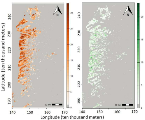
Figure 1: The map on the left shows the number of years of soy presence from 1989 to 2021 in Western Bahia. The map on the right shows the number of years of change of soy presence during the same time series [1].
Why is this Important?
The combination of reduced availability and increased demand for water resources is triggering socio-ecological conflicts. Yet, data are insufficient concerning irrigation, its distribution on the landscape, its drivers, its socio-ecological impacts, and its effectiveness as a climate change adaptation strategy, and alternative adaptation strategies for the Cerrado and similar areas worldwide.
How satellite data are being used to inform decision making and Earth Action?
We are developing new methods to quantify gain, loss, and alternation of land classes to improve understanding of crop rotations that influence and are influenced by irrigation [1]. Satellite imagery also informs our preparations for ethnographic fieldwork with agribusinesses, government agents, and social movements that contest irrigation policy.

[1] Pontius Jr et al. 2023. Trajectories of losses
and gains of soybean cultivation during multiple time intervals in western Bahia, Brazil.
Space Week Nordeste.
Project Investigator: Robert Gil Pontius Jr, Clark University, MA, USA; Email: rpontius@clarku.edu
The opinions expressed are solely the PI's and do not reflect NASA's or the US Government's views.