Land Use Science in Action

Remote sensing based mixture modeling to study land and permafrost disturbances
- Rapidly changing environmental conditions in the Arctic, driven by amplified global warming, are impacting communities and ecosystems, particularly due to added anthropogenic impacts from energy exploration and development.
- Analysis integrating remote sensing and socioeconomic data can quantify the land disturbances and help understand societal vulnerabilities of Arctic communities.
- Critical need to quantify impacts resulting from expanding drilling in the region.
- Changes to the Arctic ecosystem provide crucial links to the global climate and biogeochemical cycles.
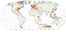
The global wildland-urban interface
A systematic assessment of global areas of potential direct human-environmental conflict
- The wildland-urban interface (WUI) is where houses and wildland vegetation meet.
- The WUI is an area of human-environmental conflict such as wildfire.
- Our new analysis mapped the WUI globally at 10-m resolution from satellite data.
- The WUI covers 4.7% of the global land and is home to half the global population.
- WUI hotspots on all continents in including the US, Eastern Africa, and South-East Asia.
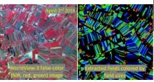
COMMERCIAL SATELLITE MADE IT POSSILE TO EXTRACT FIELDS IN SMALLHOLDER REGIONS
- Crop field boundary is an essential agricultural variable, and crop field sizes are indicative of the degree of agricultural capital investment, mechanization, and labor intensity.
- Information on delineated field boundaries and field sizes are needed for land use planning, allocation of resources, and agricultural modeling.
- Field extraction is extremely challenging in smallholder regions in Asia and Africa due to small field sizes, irregularly-shaped boundaries, narrow margins, and heterogeneities within and across fields.
- With commercial high-resolution images provided by NASA and new computer-vision algorithms, crop field boundaries are produced in smallholder regions in multiple countries in Asia.
- Agrarian transitions are studied based on characterization of field/farm size changes in multiple Asian countries.

OPERATION MERCURY CURTAILS ILLEGAL MINING IN PROTECTED AREAS TEMPORARILY
- Alluvial gold mining threatens protected conservation and indigenous lands in the tropical Amazon, particularly in Southeastern Peru.
- Federal Military Intervention Actions by the Peruvian government attempted to minimize these activities and move miners to sanctioned mining zones.
- Analyses using remote sensing data can help assess the results of this major policy action.
- NASA’s archival and ongoing data are essential for these conservation policy analyses.
- Peru’s federal policy actions reduced mining in protected areas, shifted mining into buffer unprotected zones, but there is evidence of re-mining activity as enforcement waned.
CRUCIAL ECOSYSTEM SERVICE FOR CLIMATE CHANGE ADAPTATION AT THE SAME TIME.
- Tree-based sinks are the only actions that remove excess carbon now.
- TOF at the scale of individual trees underpin livelihoods of billions of people and lead to more stable incomes under climate-stress conditions.
- NASA earth observations make individual tree carbon measurement counting part of Nature-Based Climate Solutions (NBS); this project mapped every tree in Africa.
- TOF NBS support most international programs, and White House U.S. Net Zero goals.
- Large capital investments are being made in NBS, and TOF solutions increase the relevancy and effectiveness for people’s well being and poverty alleviation.