Land Use Science in Action

LCLUC ANALYSIS CAN SHIFT IRRIGATION POLICY FOR CLIMATE ADAPTATION
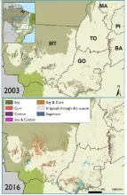
- Agricultural expansion in the Brazilian Cerrado drives the loss of primary vegetation and the gain of irrigation for export-oriented monocultures of soy, maize, and cotton.
- Climate change reduces water availability, increases water demand, and aggravates socio-ecological conflicts.
- Understanding irrigation, specifically its distribution, effectiveness, and alternatives, is essential for understanding adaptation to climate change.
- Development of LCLUC methods is essential to analyze drivers and impacts of land change.

Research on specific physical processes associated with urbanization to assess the impact of urban land conversion on regional-scale surface climate and its impact on society.
- Urbanization affects surface climate by reducing the vegetation fraction, transpiration, water infiltration and consequent increase in surface runoff and flash-flooding
- Mapping the extent of urban land conversion allows to assess the impact of land cover and land use and provides means to prioritize actions.
- Modeling land surface processes using remote sensing will strengthen the predictive
capabilities and offer a baseline for decision making and planning

Wildfire risk varies with shifting landcover and land use practices in southern Greece
Diverse landcover in the Mediterranean region necessitates localized approaches to reduce fire risk
- Urgent need for fire risk analyses given projected increase in Mediterranean wildfire activity
- Landcover and land use changes can both increase and decrease fire risk
- Remote sensing, combined with fire simulation modeling, can identify areas with high wildfire exposure and detrimental impacts
- NASA’s Earth observation record provides critical data for assessing risk change over time
- Modeled fire risk is essential for guiding landowner and resource manager decision making

ENABLING HARM REDUCTION FROM EXTREME HEAT IN A WARMING CLIMATE
- The Arabian Peninsula already suffers from the most extreme heat on the planet.
- Climate Chance and Land-Cover and Land-Use Change are amplifying extreme heat across the Arabian Peninsula, impacting human health.
- Fusing remote-sensed LCLUC and climate data with weather models can improve extreme heat forecasting and climate projections.
- NASA’s Earth Observation platforms can enable the operationalization of monitoring and forecasting of extreme heat and guide adaptations to reduce harm to improve health.
Characterizing land-use transitions helps combat climate change impacts and informs land-use policy
- The most biologically diverse savanna on earth is a major frontier of LCLUC
- It is yet unknown where high-impact land-use transitions are concentrated and the main drivers of those changes
- Urgent need to develop detection methods and novel data sets to inform decision-making a to address biodiversity loss and mitigate climate change impacts
- Use of Earth Observation data, time series analyses, and machine learning algorithms to expand the spatial and temporal data on agricultural development and a novel data set on irrigated agriculture in combination with spatial analyses of socioeconomic influences