Land Use Science in Action
Characterizing land-use transitions helps combat climate change impacts and informs land-use policy
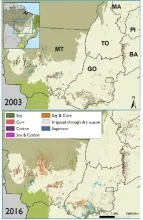
- The most biologically diverse savanna on earth is a major frontier of LCLUC
- It is yet unknown where high-impact land-use transitions are concentrated and the main drivers of those changes
- Urgent need to develop detection methods and novel data sets to inform decision-making a to address biodiversity loss and mitigate climate change impacts
- Use of Earth Observation data, time series analyses, and machine learning algorithms to expand the spatial and temporal data on agricultural development and a novel data set on irrigated agriculture in combination with spatial analyses of socioeconomic influences

DIFFERENT APPROACH TO U.S. DRUG POLICY NEEDED TO MEET CONSERVATION GOALS
- Counterdrug interdiction pushes cocaine trafficking into biodiverse landscapes.
- Analyses integrating remote sensing and socioeconomic data can identify and quantify land use/cover-change caused by illicit economies.
- Urgent need for such analyses to inform action to mitigate climate change and biodiversity loss in Central America.
- NASA’s role in Earth observation is essential for evaluating long-running U.S. policies.
- Long-term effects of U.S. drug policy undermine international conservation efforts.

POTENTIAL INCREASES IN WATER SCARCITY AS THE AGRICULTURAL SECTOR ADAPTS
- Water scarcity in agricultural regions is worsening as the Earth warms.
- Urgent need for local and regional analyses to formulate precision adaptation measures.
- Analyses integrating remote sensing, hydrological modeling, and economic modeling can
project future water scarcity and farmers’ responses via crop choice and irrigation investment. - NASA’s Earth observations are critical to track short-term (crop growth and seasonal water
use) and long-term (crop system transitions, irrigation investment) agricultural responses to
drought and target climate adaptation measures.