Whats New
Online Lecture by Prof. Jiquan Chen "Sustainability Challenges for the Socio-Environmental Systems across the Asian Drylands Belt"
November 03, 2021
Professor Jiquan Chen from Michigan State University, who is currently a Fulbright Global Scholar in Germany, will be giving an online lecture on “Sustainability Challenges for the Socio…
GOFC-GOLD CARIN Webinar Series
November 03, 2021
Central Asia Regional Information Network (CARIN) Research Webinar.
When: Nov 5, 2021 09:00 AM Eastern Time (US and Canada)
Dr. Sagynbek Orunbaev of the Department…
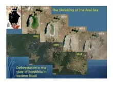
An opportunity to contribute papers to a Special Edition on Half-a-Century Landscape Dynamics Observed From Space
October 19, 2021
Celebrating 50 years of Landsat data, Garik Gutman (LCLUC Program Manager) is leading a Special Edition of papers applying decadal time-series data from Landsat, AVHRR,MODIS to study…
Release of MuSLI Land Surface Phenology V1.1 Data Product
August 27, 2021
August 26, 2021
By: LP DAAC
The LP DAAC is pleased to announce the availability of NASA’s Multi-Source Land Imaging (MuSLI) Land Surface Phenology (LSP) Version 1.1 Yearly…
Copernicus Water Quality Project
August 18, 2021
Please get acquainted with activities, aims and expectations of a Copernicus Service Evolution project within the Research and Innovation Action program of the H2020 framework. Being part of…
Esri Releases New 2020 Global Land Cover Map
July 08, 2021
Esri releases first-ever high-resolution (10-meter), 2020 global land cover map. The map was built using European Space Agency (ESA) Sentinel-2 satellite imagery and developed using a new…