changes in the Amazon region for use in Earth system models.
- The Amazon forest is important for atmospheric dynamics, biodiversity, and the water cycle.
- Land-use change in the Amazon, such as wood harvesting, shifting cultivation, and deforestation
is large with large uncertainty. - Earth system models (ESMs) currently rely on coarse-resolution land-use datasets to compute
the effects of land-use / land-cover change on both local and global atmospheric dynamics. - This study uses lidar observations and a novel modeling approach to reconstruct monthly
high-resolution forest cover change over the previous 20 years, for use in ESMs.
How is land use/cover being changed?
Forest dynamics in the Amazon region are changing, including significant deforestation and degradation. Between 2001 and 2020 the Amazon lost over 50 million hectares of forest. Our new high-resolution, lidar-constrained monthly timeseries of forest cover dynamics (Fig. 1) is the first step towards building a digital twin of land cover changes in this region, to be be used by ESMs such as the NSF NCAR CESM, as well as used to inform land-use change products.
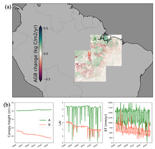
Figure 1: Reconstructed historical dynamics of (a) above-ground biomass (AGB), (b) canopy height, leaf-area-index (LAI), and evapotranspiration (ET) from 2000 to the present for two selected regions in the Amazon, one experiencing deforestation and one undisturbed.
Why is this Important?
Land-use change in the Amazon has significant impacts on local-regional atmospheric dynamics through changes in radiation, momentum, moisture, and heat fluxes. These changes will be felt by the 30 million people who live in the Amazon region. In addition, forest cover change has a large impact on atmospheric carbon fluxes.
How satellite data are being used to inform decision making and Earth Action?
Satellite-based lidar from NASA GEDI and ICESat-2 provides high-resolution observations of forest canopy height. When integrated into the Ecosystem Demography model (ED), we can reconstruct an historical monthly time-series of 1km forest cover change consistent with these observations [1]. This enables more accurate and detailed understanding of the impacts of land-use and land-cover change local-regional atmospheric dynamics.
References
[1] Ma, L., et al. (2023). Spatial heterogeneity of global forest aboveground carbon stocks and fluxes constrained by spaceborne lidar data and mechanistic modeling. Global Change Biology. https://doi.org/10.1111/gcb.16682
Project Team: Louise Chini (PI, University of Maryland, MD, USA; Email: lchini@umd.edu), George Hurtt, Lei Ma, David Lawrence, Peter Lawrence
The opinions expressed are solely the project team’s and do not reflect NASA's or the US Government's views.