- Urbanization affects surface climate by reducing the vegetation fraction, transpiration, water infiltration and consequent increase in surface runoff and flash-flooding
- Mapping the extent of urban land conversion allows to assess the impact of land cover and land use and provides means to prioritize actions.
- Modeling land surface processes using remote sensing will strengthen the predictive
capabilities and offer a baseline for decision making and planning
How is land cover/use changed?
Moroccan cities have high growth potential, particularly in terms of land use and verticality. However, urban policies need improvement to accommodate the growing number of households forced to live in urban outskirts because of housing prices, and more generally to address environmental, economic, and social issues and regulate urban development. Research on urbanization is needed to better understand and assess its impact on local surface climate and its impact on society.
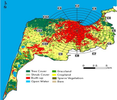
Figure 1: Land cover and Land use for the region of Tangier (Morocco) (El Ghazouani et al., 2021)
Why is this Important?
Urbanization represents a small fraction of land transformation; however, it occupies earth’s most productive lands, and its ecological impact is significant and long lasting. In this north African region, about 80% of the population live in 20% of the land, and fertile agricultural lands are being consumed for urban purposes. For climate, this has similar effect as an advance of the desert.
How satellite data are being used to inform decision making and Earth Action?
Satellite data introduces an unavoidable tool to map and assess land cover and land use globally, especially in remote inaccessible areas around the world. They allow for a global assessment.

Environ. Research. Letter. 10 (2015) 084010
Project Investigator: Lahouari Bounoua (PI) NASA – GSFC, MD, USA; Email: Lahouari.Bounoua@nasa.gov
The opinions expressed are solely the PI's and do not reflect NASA's or the US Government's views.