- Developed a satellite imagery-based map of coastal land degradation on working lands.
- Sea level rise impacts interact with landowner decisions, not just physical processes.
- Landowner risk perception and social interactions are key drivers of adaptation actions.
- A spatially explicit agent-based model linking NASA Earth observations, sea level projections, and human decision-making will help to identify the impact of human decision-making on coast landcover change under future scenarios.
How is land use/cover being changed?
Sea level rise is reshaping coastal working lands of the mid-Atlantic United States through saltwater intrusion, forest dieback, agricultural degradation, and marsh migration [1,2]. Using Sentinel-2 multispectral imagery, Landsat time-series analysis, and LiDAR elevation data, we developed a moderate-resolution (10 m) satellite-based degradation map capable of detecting early ecosystem transitions. Satellite observations reveal retreat of coastal forests, formation of ghost forests, and increased disturbance following major storm events such as Hurricane Sandy, with impacts concentrated at low elevations vulnerable to future inundation. These results demonstrate that remotely sensed data can identify coastal change well before permanent land-cover conversion occurs.
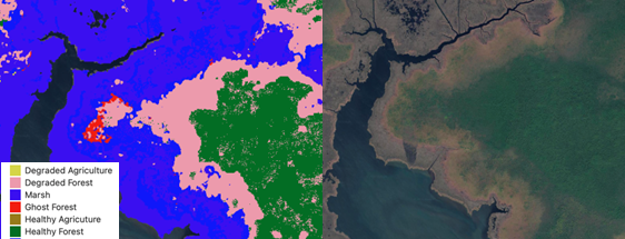
Figure 1: Map of saltwater degradation (left) compared to satellite imagery.
Why is this Important?
Coastal ecosystems support agriculture, forestry, biodiversity, and rural economies, yet predicting their future under sea level rise requires understanding both environmental change and human responses. Survey responses from 1,120 farm and forest landowners indicate that perceived risk of saltwater impacts, social discourse, and engagement with organizations significantly increase the likelihood of adaptation actions such as conservation enrollment, management changes, or shoreline armoring [3]. These findings highlight that coastal land-use change emerges from coupled human–natural systems rather than climate drivers alone.
How satellite data are being used to inform decision making and Earth Action?
We integrated remote sensing products, landowner behavioral models, and sea level rise projections into a spatially explicit agent-based modeling framework. By linking NASA Earth observations directly to human decision processes, this work transforms satellite data into actionable tools for coastal resilience planning and climate adaptation.
![]()
[1] Kirwan & Megonigal, 2013. Nature, 504:53-60. [2] Schieder et al., 2018. Ecol. Appl., 28(6). [3] Beall et al. In review.
Project Investigator: Elizabeth Hunter, U.S. Geological Survey, Virginia Tech, VA, USA; Email: ehunter1@vt.edu
The opinions expressed are solely the PI's and do not reflect NASA's or the US Government's views.