Transboundary regions are particularly susceptible to unplanned LCLUC due to fragmented governance despite proximity. A holistic understanding of LCLUC and their drivers in transboundary regions is crucial for more effective water management. An Earth Observations to Decision Making (EO2DM) pipeline is being implemented to address two critical challenges: (1) insufficient long-term, high-resolution transboundary landuse data, and (2) the lack of socio-environmental modeling frameworks capable of integrating human and natural system dynamics. This project has developed the first 30-year (1994–2024), 30 m annual Crop & Land Cover Land Use (CLCLU) dataset for the binational Middle Rio Grande (MRG) region [1] and identified, through a systematic review, the need for hybrid stakeholder-informed LCLUC models [2].
How is land use/cover being changed?
Transboundary regions operate under different administrative policies but remain interconnected through shared resources. This is particularly evident in the transboundary (US-MX) Middle Rio Grande (MRG), where water management faces increasing pressure. The lack of consistent and complete data across both sides of the border has historically limited comprehensive analysis. Our publication and datasets [1] addresses this gap by providing the first annual, binational, crop-specific and land cover dataset for the region, enabling improved understanding of long-term LCLUC dynamics. To complement remote sensing analysis and better understand underlying drivers of change, stakeholder interviews will capture local perceptions, institutional knowledge, and mental models of the socio-environmental system, as supported by [2].
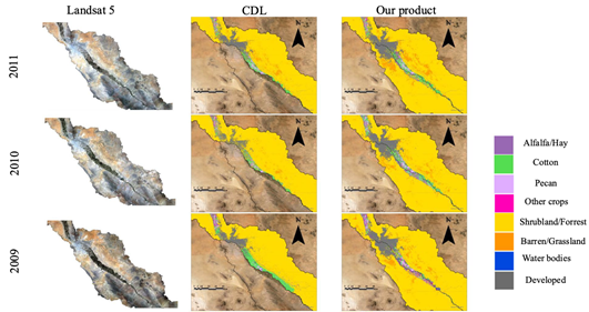
Figure 1: Comparison of Landsat imagery, CDL, and the developed 30-year CLCLU product, demonstrating improved crop-specific and transboundary land-use classification in the Middle Rio Grande.
Why is this Important?
Understanding the sustainability of LCLUC in transboundary regions is critical for managing common-pool resources such as water. This project addresses two fundamental limitations: (1) insufficient spatial and temporal land-change data [1], and (2) the absence of modeling tools that effectively link socioeconomic drivers with biophysical processes [2]. By combining long-term Earth observation data with stakeholder-informed socio-environmental modeling, the EO2DM framework strengthens the scientific basis for adaptive and climate-aware water management strategies in water-constrained transboundary systems.
How satellite data are being used to inform decision making and Earth Action?
Earth observations derived from [1] provide annual, high-resolution CLCLU maps for the MRG region. These data is integrated with stakeholder knowledge and perceptions to enhance decision-making for sustainable land and water policies. Other EO derived datasets such as LAI and ET are used to calibrate decision making models
References
[1] Ebrahimi et al., 2025. Scientific Data, 12: 1462. [2] Neri-Barranco et al., 2026. JLUS, 21(1), 126-149.
Project Investigator: Saurav Kumar, Arizona State University, AZ, USA; Email: sk2@.asu.edu
The opinions expressed are solely the PI's and do not reflect NASA's or the US Government's views.