- The wildland-urban interface (WUI) is where houses and wildland vegetation meet.
- The WUI is an area of human-environmental conflict such as wildfire.
- Our new analysis mapped the WUI globally at 10-m resolution from satellite data.
- The WUI covers 4.7% of the global land and is home to half the global population.
- WUI hotspots on all continents in including the US, Eastern Africa, and South-East Asia.
How is land use/cover being changed?
The wildland-urban interface (WUI) is where buildings and wildland vegetation meet or intermingle. Globally, the growth of WUI is driven by the expansion of human settlements into (semi-)wildland ecosystems, or, more rarely, by vegetation regrowth. The WUI covers only 4.7% of the land surface but is home to nearly half its population [1]. The WUI is on all continents, with hotspots, e.g., in the United States, Europe, Brazil, Western and Eastern Africa, and Eastern and South-Eastern Asia, many of which were and are lacking research. Two-thirds of the global WUI is dominated by forests, shrublands, and wetlands versus one-third by grasslands. The WUI is an area of increased human-environmental conflicts and risks, including biodiversity loss, the spread of zoonotic diseases, but also the loss of houses and lives to wildfire [2, 3].
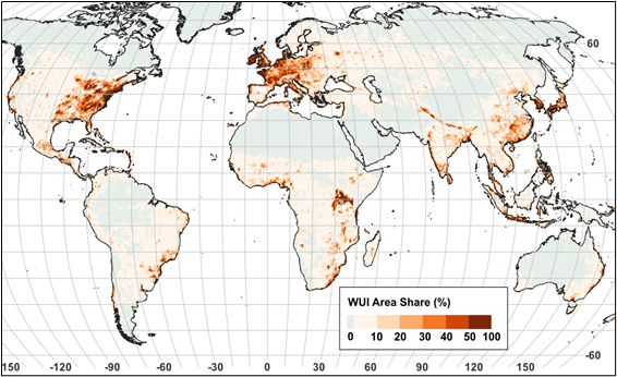
Figure 1: Area share of the global Wildland-Urban Interface (Schug et al., 2023).
Why is this Important?
Globally, 400 million people lived near wildfires in the last two decades. Two-thirds of them have their home in the WUI, especially in Africa (150 million). The growing population along with predicted increased wildfire activity due to climate change in many regions underlines the urgency to understand the WUI and its drivers across all scales because wildfires can be a direct economic and social threat to people.
How satellite data are being used to inform decision making and Earth Action?
Openly available high-resolution optical imagery enables alobal systematic and consistent assessment and monitoring of the WUI. This allows for both identifying global patterns of potential human-environmental conflict, a relevant metric to international agreements and frameworks, and high-resolution insights, relevant to local planning processes and resilience-building.

[1] Schug et al., 2023. Nature, 621: 94-99. [2] Radeloff et al., 2018. PNAS, 115(13). [3] Bar-Massada et al., 2014. BioScience, 64(5).
Project Investigator: Volker Radeloff, University of Wisconsin-Madison, WI, USA; Email: radeloff@.edu
The opinions expressed are solely the PI's and do not reflect NASA's or the US Government's views.