- LCLUC has critical impacts on meteorology and local- to global-scale climate.
- Improved representation of LCLU, and methods to quantify the impacts of LCLUC on meteorology, gained from this project will aid the development of NASA’s L-ESDT.
- Updated LCLU maps from Landsat improved WRF urban air temperature predictions by ~50%.
- This project will produce the first-ever fractional contribution budget of the major landscape transformation processes on changes in local- to regional-scale meteorology.
How can weather model performance be improved through the application of satellite-derived LCLU data?
This NASA-funded LCLUC Program project will provide critical information for the development of NASA’s Land-Earth System Digital Twin (L-ESDT) about a) what LCLU maps should be applied in the system to increase forecast accuracy and b) methods to be applied by users to test the impact of LCLUC on meteorology. Studies have demonstrated that implementing high spatiotemporal resolution LCLU data from spaceborne sensors into numerical weather models such as WRF, replacing the outdated baseline LCLU data sets which are provided upon download of the model, results in improved meteorological forecast skill. Initial results from our study show that replacing outdate LCLU information in WRF with high spatial resolution, year specific Landsat NLCD and LCZ data, along with updated urban fractions, results in improved model forecast accuracy for critical meteorological variables (e.g., 2-m air temp.) [1] (see Fig. 1).
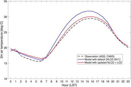
Figure 1: WRF comparison to urban 2-m air temp. obs.
Why is this Important?
The improved representation of LCLU, and methods of how to quantify the impacts of LCLUC on meteorology, gained from this proposed project can be applied in the development of the L-ESDT which will aid users in various applications and decision-making processes which have societal implications, such as the impact of LCLUC on local- to regional-scale weather/climate (e.g., urban heat effects, energy/moisture perturbations from agriculture/irrigation, etc.).
How is satellite data being used improve the estimate of LCLUC impact on local-scale weather?
Replacing outdated LCLU information in WRF (NLCD 2011) with year-specific Landsat NLCD 2020 data, and improved urban classification through satellite-derived Local Climate Zone (LCZ) extensions, improves the accuracy of WRF sensible heat flux and air temperature. This is directly due to the better representation of LCLU driving land surface model predictions in the model. Next steps in the project will be to update vegetation (MODIS LAI/fPAR) and agriculture/irrigation (Landsat) maps in WRF using satellite data.

[1] Johnson, M. S., et al., (2026), Improving Numerical Weather Forecasts with More Representative Land Surface Modeling: Implementation of Updated Satellite-Derived Land Cover and Land Use Change Maps, AMS 2026, Houston, TX, January 2026
Project Investigator: Matthew Johnson, NASA Ames Research Center, CA, USA; Email: matthew.s.johnson@nasa.gov