·More than 50% of the population lives in cities, and the urbanization trend continues.
·Albedo is the most important factor in improving urban climate simulation.
·Current models still employ tabulated albedo values with limited spatial variability
·We developed a new dataset of urban albedo using Landsat and building footprint data
·The new dataset will be integrated into WRF for urban climate simulation
How does albedo affect urban climate?
In urban areas, albedo can vary substantially depending on the material and color of the roof and surface [1]. Land cover and land use change (LCLUC) also needs to be accounted for in the land surface models, as it can significantly alter the albedo [2]. Climate change mitigation strategies widely adopted in urban areas, such as white roofs, green roofs, and urban green spaces, rely directly on changes in albedo to achieve cooling effects [3]. Urban land surface models of various complexities have been developed to simulate the radiation and turbulent energy exchange processes in urban environments. Correctly characterizing the albedo of building materials is identified as the most important factor in improving urban simulations. Integrating spatially explicit albedo into urban climate models will improve the simulation of urban meteorology at the weather scale, thereby empowering stakeholders to better navigate urban planning and policies in a changing climate.
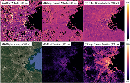
Figure 1: Modeled albedo of the roof and ground impervious surfaces at 500m resolution
Why is this Important?
With more than 50% of the global population living in cities and the continued urbanization trends, urban areas represent critical hotspots of water, energy, and health challenges facing humanity in the 21st century. A better understanding and prediction of urban microclimate and hydrology within the context of global environmental change plays a key role in tackling these challenges.
How satellite data are being used to inform decision making and Earth Action?
Openly available high-resolution optical imagery enables the estimation of albedo globally. Building footprint data created using very-high-resolution images enables the partitioning of roof and impervious ground albedo. We combined Landsat-based multi-temporal blue-sky albedo, global building footprint data, and NLCD impervious surface layers to estimate roof and impervious ground albedo at various resolutions, which will then be used to improve urban simulation using WRF.

[1] Trlica et al., 2017. Earth's Future, 5(11), 1084-1101. [2] Ghimire et al., 2014. GRL, 41(24), 9087-9096. [3] Wang et al., 2021. ERL, 16(8), 084062
Project Investigator: Xiaojing Tang, James Madison University, VA, USA; Email: tang3xx@jmu.edu
The opinions expressed are solely the PI's and do not reflect NASA's or the US Government's views.