- Urban densification drives stronger nocturnal surface Urban Heat Island (UHI) intensification than horizontal expansion across four Indian megacities.
- Nighttime heat accumulation is controlled by urban morphology; densification increases building heights and impervious fraction, trapping longwave radiation in deep street canyons.
- LCZ-based urban trajectory framework enables explicit attribution of decadal temperature changes to urban expansion vs. densification at 375 m spatial resolution.
How is land use/cover being changed?
Urban growth in Indian cities follows two pathways: horizontal expansion into non-urban land, and internal densification through infilling and vertical growth. Machine-learning LCZ maps for 2013 and 2024 enable a novel trajectory framework to explicitly separate these modes. Each pathway alters radiative exchange, thermal mass, and ventilation through distinct physical mechanisms—producing unique thermal fingerprints now quantifiable at 375 m resolution using VIIRS LST.
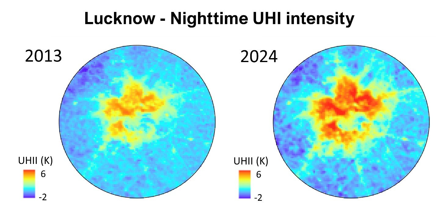
Figure 1: Increases in nighttime Urban Heat Island (UHI) intensity (degree K) from 2013-2014 for Lucknow, India.
![]()
![]()
![]()
![]()
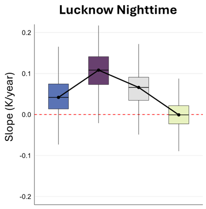
Figure 2: UHI trends (degree K/yr) for Lucknow shows that urban densification drives nocturnal warming
Why is this Important?
In India, a country where more than a billion people already face increasingly frequent and deadly heat events, identifying a climate resilient pathway to urbanization is critical.
India's rapidly expanding cities face worsening heat risk, yet urban heat policy treats all growth the same. This study shows that how cities grow matters as much as how much they grow.
Densification—often promoted as sustainable for limiting sprawl—is in fact a stronger driver of nighttime heat stress than outward expansion (Fig 2). Because nocturnal heat exposure carries greater health and mortality risk than daytime warming, densification without thermal governance can silently elevate heat risk even where daytime temperatures appear stable.
How satellite data are being used to inform decision making and Earth Action?
VIIRS 375 m land surface temperature (LST) provides a rare combination of spatial detail and daily temporal continuity, enabling fine-scale urban heterogeneity and decadal surface UHI evolution to be jointly resolved (Fig 1). When combined with multi-year LCZ maps from Landsat and Sentinel-2 data, the satellite record enables explicit attribution of thermal change to distinct urban growth modes.

Yoo et al., (2026), Urban densification outweighs urban expansion in shaping nocturnal urban warming across Indian cities
Nature Cities, in press.
Project Investigator: Glynn Hulley, Jet Propulsion Laboratory, California Institute of Technology; glynn.hulley@jpl.nasa.gov
The opinions expressed are solely the PI's and do not reflect NASA's or the US Government's views.