- Urgent need for fire risk analyses given projected increase in Mediterranean wildfire activity
- Landcover and land use changes can both increase and decrease fire risk
- Remote sensing, combined with fire simulation modeling, can identify areas with high wildfire exposure and detrimental impacts
- NASA’s Earth observation record provides critical data for assessing risk change over time
- Modeled fire risk is essential for guiding landowner and resource manager decision making
How is land cover/use changed?
Over the last three decades agricultural land expansion was 8 times greater than loss in Southern Greece, mostly due to
olive orchard expansion [1]. Recent gains in agricultural land may decrease fire risk in many areas by reducing fuel load and
continuity [2]. However, land use practices, such as clearing understory vegetation in agricultural areas are not consistently
practiced. Other fire risk drivers include natural vegetation densification, which was observed to increase in nearly all areas
of Southern Greece over the same time period.
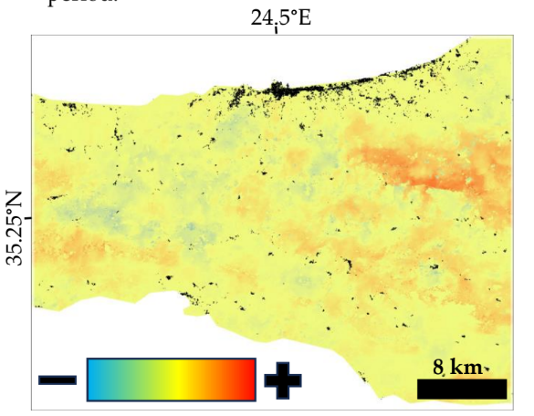
Figure 1: Change in the likelihood of wildfire from 2000 to 2020 in the Rethymno prefecture of Crete, Greece. Human settlements are colored in black.
Why is this Important?
Given projected favorable climatic conditions, future wildfire activity in the Mediterranean is expected to increase [3]. Consequently, an improved understanding of how landcover change and land use practices affect wildfire risk is critically needed by communities, land managers and policy makers for development of solutions that reduce detrimental impacts of fire [4].
How satellite data are being used to inform decision making and Earth Action?
Landsat time series data, combined with ground observations are being used to map landcover change and fuel type over 3+ decades. This remotely sensed data provides critical spatially explicit input data for wildfire simulation modeling, which can be used by landowners and natural resource managers to identify areas where actions may be needed to reduce fire risk.

[1] Sparks et al. Rem. Sens. 14 (2022). [2] Xanthopoulos et al. RMRS-P-41 (2006). [3] Doblas-Reyes et al. IPCC (2021). [4] Moreir and Pe’er Science 359 (2018)
Project Investigator: Aaron Sparks, University of Idaho, ID, USA; Email: asparks@uidaho.edu
The opinions expressed are solely the PI's and do not reflect NASA's or the US Government's views.