Mapping Urban Expansion Using Multi-Decadal Landsat And Nightlights Data Over North America
Urbanization is among the most rapid and visible types of landscape transformations with climatic, hydrological, biophysical and ecological impacts on the environment. To quantify the impacts of such transformation urban areas should be characterized in terms of both the density of impervious areas and vegetated cover. In this project we use observations from Landsat and NPOESS VIIRS Day/Night Band to derive a consistent, robust, scalable characterization of the urbanization at sub-pixel resolutions.

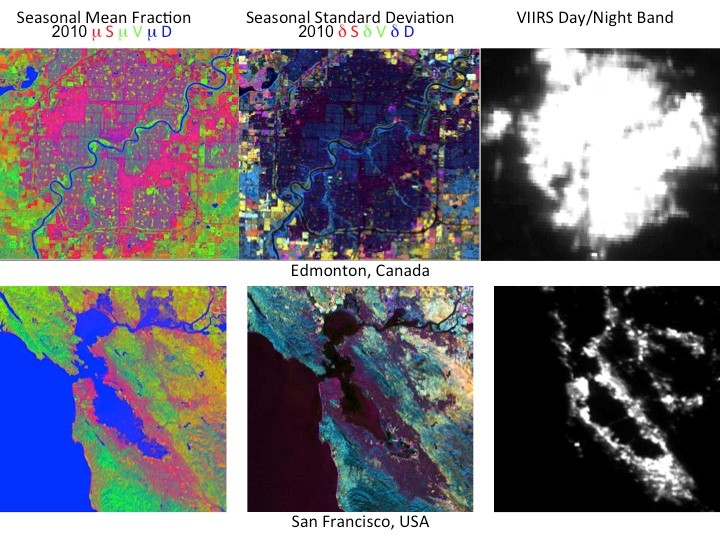
Figure 1. RGB composites of the mean (left) and standard deviations of the Substrate (S), Vegetation (V) and Dark (D) fractions calculated from 2010 multi-season Landsat for Edmonton, Alberta, Canada (top) and San Francisco, California, USA (bottom). The images on the right show nighttime imageries of the two urban areas from the Day/Night Band from NPOESS VIIRS data. Urban land use is denoted by substrates that are dominant (in red in the left images) but with low temporal variability (in dark in the center images) over pixels that are lit in the nighttime image (right).
The approach used here is based on the observation that at the Landsat resolution (30-m), the reflectance of each pixel is the result of the mixture of materials contained within the pixels and can be approximated through a linear mixture model. We developed a standardized linear mixture model that can be applied to any Landsat scene independently from the geographic location and time of year. Inversion of the mixture model converts the Landsat reflectance to subpixel areal estimates of Substrate (S), Vegetation (V) and Dark (D) materials. In the built environment we find higher fractions of S, interbuilding D shadows, and smaller but varying amounts of vegetation. Since the fraction “Dark materials” cannot be associated to a unique land cover, a transformation redistributes the dark fractions to substrate and vegetation reducing the mixing space to 2 fractions. To build a standardized mixture model we select endmembers from a sample of global Landsat TM and ETM spectral mixing space representative of the biomes within the global land area and of their spectral diversity. The robustness of the approach has been validated vicariously with a spectral mixture model derived from WorldView-2 images over New York City and with an independent data set of ground fractional cover measurements for a diverse set of agricultural crops.
Urban land use is identified based on the intra-annual mean and variability in the spectral endmembers of pixels for which the Day/Night Band from VIIRS data indicates the presence of urban agglomerations. Pixels with an urban land use can be distinguished from other land uses based on the higher fraction of substrates with lowest temporal variability. Examples of the mean fractions, their interannual variability and the VIIRS Day/Night Band are shown for Edmonton, Canada and San Francisco, California, USA in Figure 1. The algorithm is implemented over the North American continent and the 2010 Urban Vegeation Fraction is shown in Figure 2. Read more about the project
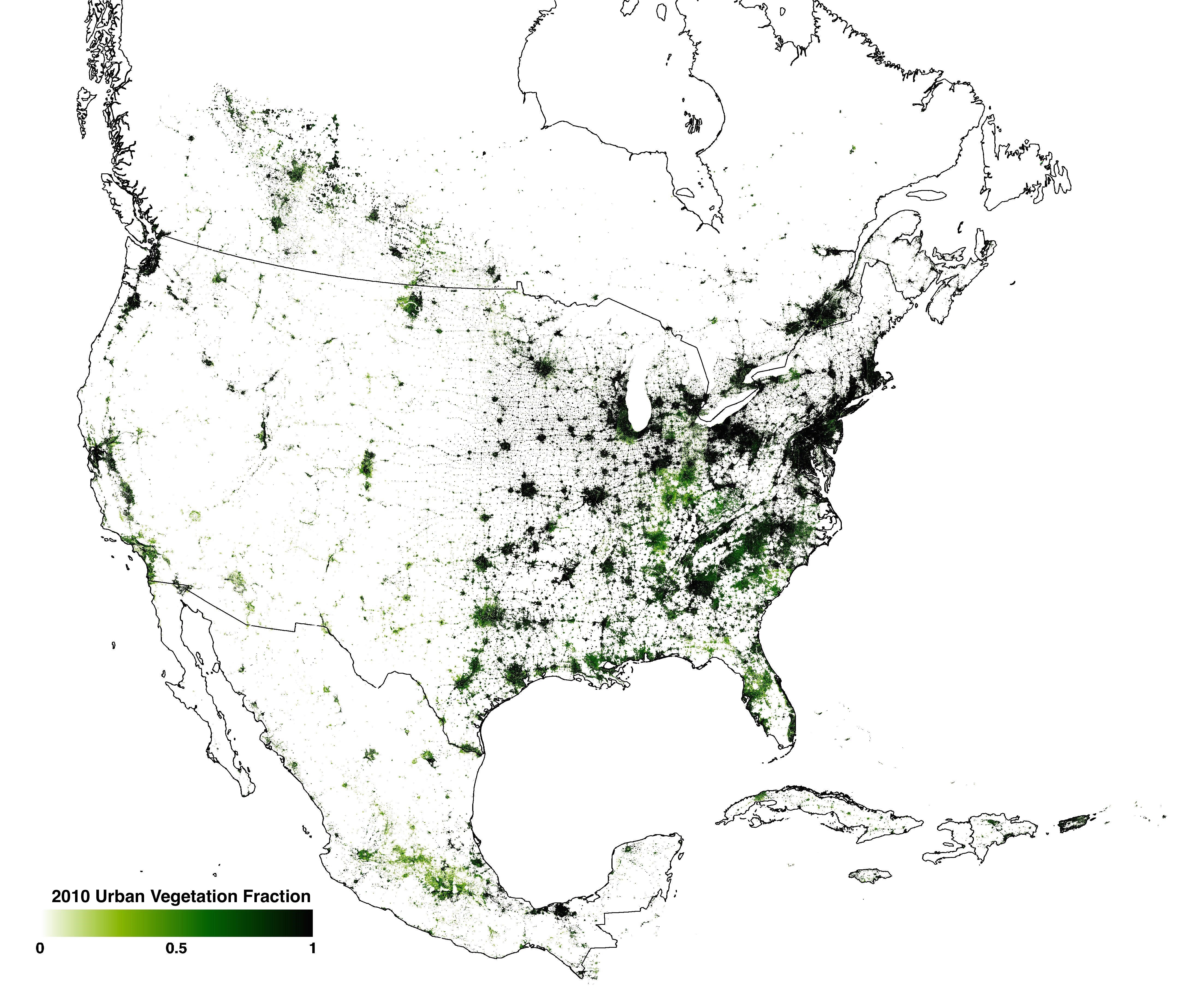
Figure 2. 2010 Urban Vegetation Fraction for North America.