Investigating land-use/cover changes along the East-West Economic Corridor in Vietnam, Laos, and Thailand
The specific objective of this project is to understand the role that improved transportation routes especially new roads and connectivity have on both urban and rural land-cover/land-use. The recent webinar presented some of the preliminary results of this project and looked at changes that have taken place within the East-West Economic Corridor (EWEC) in Vietnam. The talk specifically addressed: (1) Changes in the urban land-cover within the EWEC in Vietnam (2) Changes in the rural land-cover within the EWEC in Vietnam, and (3) The drivers of these changes, urban-rural connectivity and the role of roads. This short paper focuses on the second and third of these points.
In the Vietnamese part of the corridor urban areas have exhibited infilling as well as new and expanded industrial zone development. Da Nang City and Hue City have both seen a large expansion of residential areas and infilling of previous open areas within the city with infrastructure and businesses related to the tourism sector, while Da Nang City and Dong Ha city have seen new industrial zone development and the introduction of new industries. The drivers of these changes are investments in the tourist industry and industrial zones from the urban areas of Hanoi and HCMC and from abroad.
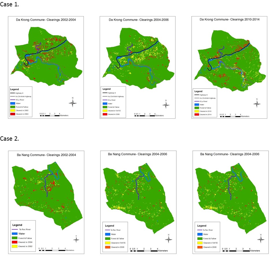
The changes in the rural areas of the EWEC in Vietnam are are mostly concentrated in Quang Tri province. New agricultural crops have been introduced to the rural areas by agents of the newly invested starch factories and wood processing factories within two new industrial zones in Dong Ha City. During the webinar we presented two village cases illustrating the rural land-cover changes. In the first village evidence of the change in cultivated field placement from deep within forested areas to the roadside was presented (Figure 1, Case 1).

Figure 1.Comparison of field placement in two cases.
The reason for this field placement change is due to a change in what is grown. Farmers have decreased their cultivation of upland rice and increased cultivation of hybrid, industrial, cassava, which was introduced to the village by extension agents from the new starch factories. Cassava is heavy and difficult to transport, so placement of the fields near the road means that it is easier to get the cassava to the road and sell it to middlemen who transport it to the starch factories in Dong Ha. In areas farther from the road, acacia trees (promoted by the wood processing industry) are now being planted in fallow fields. The impact on the land-cover appears to be a shift of cleared fields from distant, forested, areas of the village to locations near the road, and an overall decrease in shifting cultivation fields away from the road.
The second village case study is in the same district as the first, but until the road upgrade was completed this village was isolated. Even though shifting cultivation was practiced, the number of active fields were limited and scattered, as the main crop was upland rice and used for subsistence purposes. After secondary roads were built to the village, the number of active upland fields expanded (Figure 1, Case 2). With the road expansion, the village was introduced to hybrid cassava, by extension agents and middlemen from the new starch factories. The impact on the land-cover appears to be the expansion of upland fields in the village, both near and far from the roads. In contrast with the situation in the first village, there appears to be a decrease in tree cover in the village.
Based on our research so far, it is clear that the urban growth in Da Nang, Hue, and Dong Ha is being driven by external investments in the tourism industry and industrial zones. This investment is being transmitted to rural areas within the corridor via extension agents in the form of demand for new agricultural and tree crops. This, in turn, is driving land-use and land-cover changes. In the 1990s and 2000s there was an underlying theme presented in the land-use/cover change literature that road building in rural areas causes deforestation. Much of this work was based on research done in the Amazon. Our preliminary findings present a more nuanced view of the impact of road building on land-use and land-cover. Roads connect rural communities more tightly to urban areas and to market demands. This process can lead to changes in what crops are grown in the rural area as seen in both of our cases and reported to us by district and province officials as taking place in other communities. However, it is not clear that these changes drive land-cover change in a single direction. In the first case it appears that there is an increase in cassava growing and that cultivated fields have moved closer to the road; however, it also appears that less fields are being cleared further from the village, where forests are still found, and there is evidence that tree cover may be expanding further from the road, as tree crops are introduced or fallow fields recover, leading to an overall increase in tree cover in the village’s area. In the second case, however, the introduction of roads and better connections to urban areas appear to act as both a conduit for new crops being introduced to the village and to correspond to more fields being cleared and less trees on the landscape. We are continuing with this research to better understand these contrasting signals. Read more about the project