Land Use Science in Action
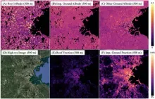
Improving urban climate simulation
by integrating remotely sensed high-resolution albedo into WRF model
·More than 50% of the population lives in cities, and the urbanization trend continues.
·Albedo is the most important factor in improving urban climate simulation.
·Current models still employ tabulated albedo values with limited spatial variability
·We developed a new dataset of urban albedo using Landsat and building footprint data
·The new dataset will be integrated into WRF for urban climate simulation
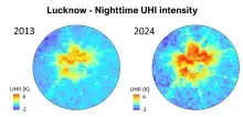
Urban Densification drives nocturnal warming in India’s Major Cities
This study investigates how urban growth modes drive nocturnal heat intensification across Indian cities
- Urban densification drives stronger nocturnal surface Urban Heat Island (UHI) intensification than horizontal expansion across four Indian megacities.
- Nighttime heat accumulation is controlled by urban morphology; densification increases building heights and impervious fraction, trapping longwave radiation in deep street canyons.
- LCZ-based urban trajectory framework enables explicit attribution of decadal temperature changes to urban expansion vs. densification at 375 m spatial resolution.

CONTINUED FOREST PROTECTION MUST BE CORE TO COMMUNITY DEVELOPMENT
- Marginal lands are now being used for crop production to feed an ever-growing population.
- Agriculture productivity must increase to meet demand, intensification rather than intensification.
- Currently, an urgent need exists for information to maximize yield based on land capabilities to mitigate land degradation, improve productivity, and to alleviate food insecurity.
- NASA's role in Earth observation is essential for merging cutting-edge modeling with very high-resolution commercial data to inform the sustainability of current land use and food security.
- Long-term effects of a lack of land tenure rights can be addressed with multi-resolution remote sensing data to relieve land pressure and move toward sustainable management practices.
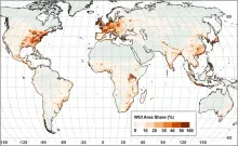
The global wildland-urban interface
A systematic assessment of global areas of potential direct human-environmental conflict
- The wildland-urban interface (WUI) is where houses and wildland vegetation meet.
- The WUI is an area of human-environmental conflict such as wildfire.
- Our new analysis mapped the WUI globally at 10-m resolution from satellite data.
- The WUI covers 4.7% of the global land and is home to half the global population.
- WUI hotspots on all continents in including the US, Eastern Africa, and South-East Asia.

Village Sustainable Planning and its influence on tropical forestry outcomes in Guyana
CONTINUED FOREST PROTECTION MUST BE CORE TO COMMUNITY DEVELOPMENT
- Carbon payment mechanisms to incentive sustainable forest management have an impact on forest loss
- Analyses integrating remote sensing and socioeconomic data can quantify the effectiveness of Village Sustainability Planning program on forest and land use
- With the rise carbon payment mechanisms for forest conservation, urgent need for such analyses is needed to inform current and future sustainable planning
- NASA’s role in Earth observation is essential for measuring and monitoring global investments in carbon markets