The Urban Transition in Ghana and Its Relation to Land Cover and Land Use Change Through Analysis of Multi-scale and Multi-temporal Satellite Image Data
The objectives of the study are to: (1) map and quantify land cover and land use change (LCLUC) within an extensive study area in Ghana from 2000 to 2010, (2) understand the regional impacts of LCLUC associated with rural-to-urban migration in driving these changes, and (3) assess LCULC and its effect on demographic and quality of life factors during this time period. We have mapped LCLU/C at two spatial scales: (1) inter-regional scale for the Ashanti, Eastern, Greater Accra, and Central regions (states) of southern and central Ghana, and (2) intra-urban scale for Accra and Kumasi, the two major cities within the study area. Inter-regional identification of LCLUC was based on moderate spatial resolution, multi-temporal image data from Landsat ETM+ and ERS-2 synthetic aperture radar (SAR) satellite systems. High spatial resolution image data from QuickBird, IKONOS, WorldView-2, and GeoEye commercial satellite systems was utilized for intra-urban mapping of LCLUC.

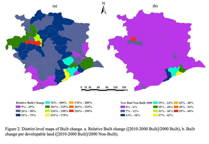
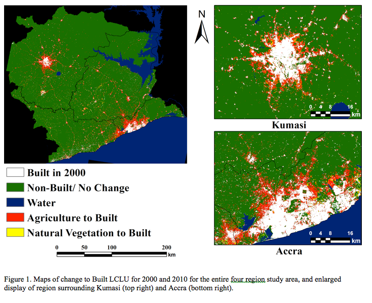
Through novel image classification approaches that exploit dense Landsat ETM+ time stacks containing extensive cloud cover, we were able to examine LCLUC at the regional scale (Fig. 1). Overall, LCLU mapping exceeds 90% accuracy with Built close to 100% accurate and LCLUC mapping accuracy close to 85%. During the study period, 1.5% of the study area transitioned to Built, an increase of 56% Built area, while population increased by 33%. Most (84%) LCLUC involved conversion from Agricultural land use and occurred predominantly in suburban and peri-urban areas of the Accra and Kumasi metropolitan areas. While total population and amount of Built variables co-vary strongly at the census district level at the beginning and end of the study period, change in population and Built are less strongly correlated. In fact, we observe new Built development increasing at a greater rate than population growth for peri-urban areas of Accra and Kumasi, frequently occurring as spaced residential land use composed of large houses with minimal infrastructural support (Fig. 2). We are able to determine the time associated with the start of urbanization based on the dense ETM+ stacks, with a precision of about 2 years.
Higher spatial resolution LCLUC mapping of Accra and Kumasi is complete and analyses of Residential and Non-residential Built development are underway. Statistical analyses and agent-based models are being applied to understand the relationship between LCLUC and rural-urban migration, as well as intra-urban health and mortality patterns. Read more about the project.