Understanding Impacts of Desert Urbanization on Climate and Surrounding Environments to Foster Sustainable Cities Using Remote Sensing and Numerical Modeling
This interdisciplinary project examines how urban infrastructure and vegetation (land cover) is distributed in and around sub-tropical desert cities and how this affects both the local and regional climate. Five regions were chosen-Las Vegas, USA; Beer Sheva, Israel; Jodhpur, India; Kharga, Egypt; Hotan/Hetian, China-to allow for a comprehensive analysis.
The project has two overall goals. One is to gain a better understanding of how land cover and land use (LCLU) distribution, patterns, and arrangements within and around these cities affect the local and regional climate as well as how changes in these elements increase or decrease heat retention or cooling in these areas. The second is to use this knowledge to support adaptive management and foster the development of sustainable desert cities.
To meet these goals, the research team is specifically exploring:
- the influences of internal urban features, land fragmentation and spatial arrangements of LCLU in both the urban space and surrounding areas;
- LCLU patterns and rates of change within and around selected cities over time (1990-2010);
- warming and climate change/variability impacts on the livability, resources, sustainability, and growth of the cities;
- the balances between oasis cooling, surface morphology, and fabric infrastructure heat storage and warming effects and their impacts over space and time;
- the magnitude and long-term influence of desert urbanization on regional precipitation, temperatures, and airflow patterns; and
- adaptation, alternate management, and land-use planning scenarios for sustainable city development in these environments.
We employ five intertwined and interconnected research approaches: A) remotely sensed image analysis; B) regional climate simulations using the Weather Research and Forecasting (WRF) Model; C) local climate simulation using the Local-Scale Urban Meteorological Parameterization Scheme (LUMPS); D) global social demographic analysis using surface temperatures; and E) land cover configuration using spatial autocorrelation.
The webinar specifically presents five interdisciplinary research studies resulting from this work to date: 1) Local-scale Urban Meteorological Analysis, 2) Land Use Land Cover Change vs. Urban Warming and Cooling, 3) Desert Urbanization and Regional Climate Change, 4) Global Demographic Analysis and Urban Heat Island, and 5) Spatial Configuration of Urban Landscapes and Land Surface Temperatures. Read more about the project
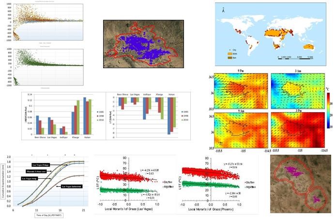
Figure 1. Desert cities and their global, regional and local climate variations.
