
Using Landsat Global Land Survey Data to Measure and Monitor Worldwide Urbanization

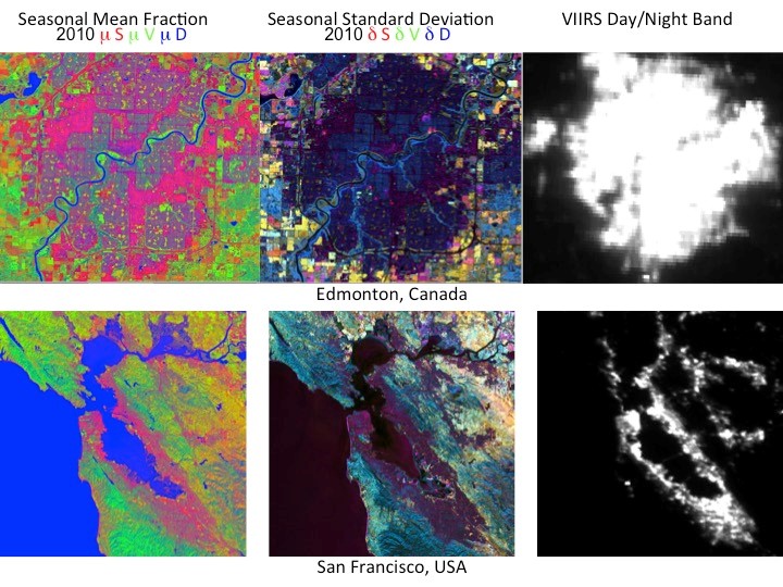
Impervious surfaces, mainly artificial structures and roads, cover less than 1% of the world’s land surface (1.3% over USA). Regardless of the relatively small coverage, impervious surfaces have a significant impact on the environment at scale from the local to the global. They are the main source of the urban heat island effect, and affect not only the energy balance, but also hydrology and carbon cycling, and both land and aquatic ecosystem services. In the last several decades, the pace of converting natural land surface to impervious surfaces has increased.

The Urban Transition in Ghana and Its Relation to Land Cover and Land Use Change Through Analysis of Multi-scale and Multi-temporal Satellite Image Data

The objectives of the study are to: (1) map and quantify land cover and land use change (LCLUC) within an extensive study area in Ghana from 2000 to 2010, (2) understand the regional impacts of LCLUC associated with rural-to-urban migration in driving these changes, and (3) assess LCULC and its effect on demographic and quality of life factors during this time period.

Impact of Urbanization on the Continental US Surface Climate

US cities are home to more than 50% of the population and this is where climate change will be felt the most. Urban communities will be interested to know how cities interact with climate and the scientific community is interested to include the urban ecosystem functions in climate models. Scientists at NASA use data fusion from Landsat and MODIS to characterize US urbanization and model its impact on surface climate. For cities built within forests, daytime urban land surface temperature (LST) is found to be higher than that of vegetated lands.

Mapping Urban Expansion Using Multi-Decadal Landsat And Nightlights Data Over North America

Urbanization is among the most rapid and visible types of landscape transformations with climatic, hydrological, biophysical and ecological impacts on the environment. To quantify the impacts of such transformation urban areas should be characterized in terms of both the density of impervious areas and vegetated cover. In this project we use observations from Landsat and NPOESS VIIRS Day/Night Band to derive a consistent, robust, scalable characterization of the urbanization at sub-pixel resolutions.

U.S. and ESA sign Sentinel data accesss agreements

U.S. and ESA sign Sentinel data accesss agreements

ESA has agreed with NASA, the National Oceanic and Atmospheric Administration (NOAA) and the US Geological Survey (USGS) to make data available to them from the European Sentinel satellites. With the third Copernicus satellite, Sentinel-3A, recently launched, ESA has signed technical arrangements with these US agencies for accessing Sentinel data. These arrangements coordinate the technical implementation covering the Sentinel data access to the US.