Land Use Science in Action
Irrigation influence on energy fluxes in the context of flash droughts
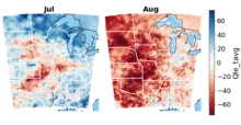
Is there any evidence that changes in representation of irrigation affects the evolution of flash droughts?
- Irrigation associated water fluxes locally improve soil moisture and humidify the atmosphere, buffering the feedback mechanism of flash droughts
- Latent heat can be expected to increase by 50% from heavily irrigated areas. (Huber et al, 2018)
- The study domain has ~34.4% of grid cells have at least some irrigated area. Heavily irrigated areas like eastern Nebraska may alter dynamics downstream.
Impacts of Urban Green Infrastructure on Extreme Events in Cities
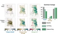
A Multi-City Digital Twin Study of the Role of Green Infrastructure in Coupled Land-Atmosphere Prediction
• Developed Noah-MP HUE —the first urban land surface model with sub-grid lateral water transfer and GI heterogeneity
• Urban vegetation in Milwaukee reduced simulated land surface temperatures by 5–15% in heavily impervious areas
• Nocturnal urban heat island reduced by ~2% and precipitation patterns improved vs. in-situ observations
• Large-scale greening reduces summer runoff and lowers daytime heat index on extreme heat days (≥90°F)
• Noah-MP HUE is coupled with WRF, enabling city-scale digital twin simulations of GI adaptation scenarios
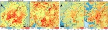
Improving numerical weather models with improved satellite LCLU maps
Developing a Digital Twin to estimate the impact of LCLUC on local-scale weather
- LCLUC has critical impacts on meteorology and local- to global-scale climate.
- Improved representation of LCLU, and methods to quantify the impacts of LCLUC on meteorology, gained from this project will aid the development of NASA’s L-ESDT.
- Updated LCLU maps from Landsat improved WRF urban air temperature predictions by ~50%.
- This project will produce the first-ever fractional contribution budget of the major landscape transformation processes on changes in local- to regional-scale meteorology.
Understanding variability of dry and web-bulb temperature across tropical cities
- Satellite land surface temperature (LST) is often used as an indicator of urban heat hazards.
- ECOSTRESS provides high-resolution LST data spanning the entire diurnal cycle.
- However, satellites do not measure the air temperatures that directly influence humans.
- We used ECOSTRESS data and land cover indices to predict dry and wet-bulb temperatures at indoor and outdoor neighborhoods in Ahmedabad and Surat.
Irrigation as climate-change adaptation in the Cerrado biome of Brazil
New quantitative methods, socio-economic analysis, and scenario models
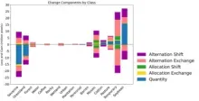
- We created methods and free software to analyze time series maps of land classes.
- Our methods quantify alternation, where a land class gains then loses at the same location.
- Transition from Savannah to Temporary Crops to Soybean is a typical sequence.
- The Total Operating Characteristic shows that Soybean gains closer to larger patches.
- Future scenarios outline a range of options for land policy and irrigation decisions.