Land Use Science in Action
Bridging LES, Remote Sensing, and WRF for Urban Climate Modeling
- Coarse NWP models poorly represent urban processes
- Missing sub-grid LCLU variability
- Anthropogenic heat (AH) is poorly constrained
Design of a EO2DM pipeline to better understand and document LCLUC and water management
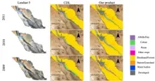
Transboundary regions are particularly susceptible to unplanned LCLUC due to fragmented governance despite proximity. A holistic understanding of LCLUC and their drivers in transboundary regions is crucial for more effective water management. An Earth Observations to Decision Making (EO2DM) pipeline is being implemented to address two critical challenges: (1) insufficient long-term, high-resolution transboundary landuse data, and (2) the lack of socio-environmental modeling frameworks capable of integrating human and natural system dynamics. This project has developed the first 30-year (1994–2024), 30 m annual Crop & Land Cover Land Use (CLCLU) dataset for the binational Middle Rio Grande (MRG) region [1] and identified, through a systematic review, the need for hybrid stakeholder-informed LCLUC models [2].
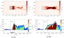
- Using multi-resolution, multi-sensor satellite imagery, create classifications of LULC and estimate physical parameters suitable for Earth System Digital Twin (ESDT) models.
- Perform large eddy simulations (LES) of Louisville, KY using a numerical model that incorporates different spatial aggregations of remotely-sensed data.
- Compare the LES simulations to field reference data captured by a micronet of meteorological stations dispersed around Louisville, KY.
- Using LES simulations simulate impacts of land cover change in the Louisville and UHI outcomes
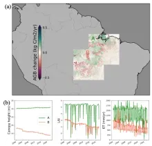
Amazon forest land-cover and land-use change
A lidar-constrained approach to building “digital twins” of historical forest-based land cover and land-use
changes in the Amazon region for use in Earth system models.
- The Amazon forest is important for atmospheric dynamics, biodiversity, and the water cycle.
- Land-use change in the Amazon, such as wood harvesting, shifting cultivation, and deforestation
is large with large uncertainty. - Earth system models (ESMs) currently rely on coarse-resolution land-use datasets to compute
the effects of land-use / land-cover change on both local and global atmospheric dynamics. - This study uses lidar observations and a novel modeling approach to reconstruct monthly
high-resolution forest cover change over the previous 20 years, for use in ESMs.
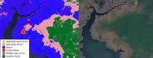
Coastal Land Change Under Sea Level Rise
A study of the interplay between land cover and landowner decisions on the east coast of the U.S.
- Developed a satellite imagery-based map of coastal land degradation on working lands.
- Sea level rise impacts interact with landowner decisions, not just physical processes.
- Landowner risk perception and social interactions are key drivers of adaptation actions.
- A spatially explicit agent-based model linking NASA Earth observations, sea level projections, and human decision-making will help to identify the impact of human decision-making on coast landcover change under future scenarios.